0
0.0
Feb 20, 2023
02/23
by
KPIX
tv
eye 0
favorite 0
quote 0
you see light shades of blue in the east bay hills and mountains. snow level could get as low as 1500 feet. that would be the highest ridge tops through places like the east bay hills. this will be an issue for anyone driving home through tahoe. tuesday afternoon it starts snowing. if people can get home tuesday morning, they will avoid this. tuesday afternoon, it is on and it keeps going. it will be cold in the mornings. even though the wind picks up tuesday into wednesday, the cold air filters in. by thursday morning, it is the upper 20s and the northbay valleys. if it's that cold in the northbay valleys, it's not as cold everywhere else, but still pretty cold. mid 30s for all of us. in the seven-day forecast, there is rain here. you see it tuesday, wednesday morng lowsce if we do get a dusting of snow on the mountains but it , regulation play is not enough for a couple of sunday sports items. >>> two words, spring training. it is here. and now - life is uncertain. everyday pressures can feel overwhelming it's okay to feel stressed, anxious, worri
you see light shades of blue in the east bay hills and mountains. snow level could get as low as 1500 feet. that would be the highest ridge tops through places like the east bay hills. this will be an issue for anyone driving home through tahoe. tuesday afternoon it starts snowing. if people can get home tuesday morning, they will avoid this. tuesday afternoon, it is on and it keeps going. it will be cold in the mornings. even though the wind picks up tuesday into wednesday, the cold air...
0
0.0
Feb 27, 2023
02/23
by
KRON
tv
eye 0
favorite 0
quote 0
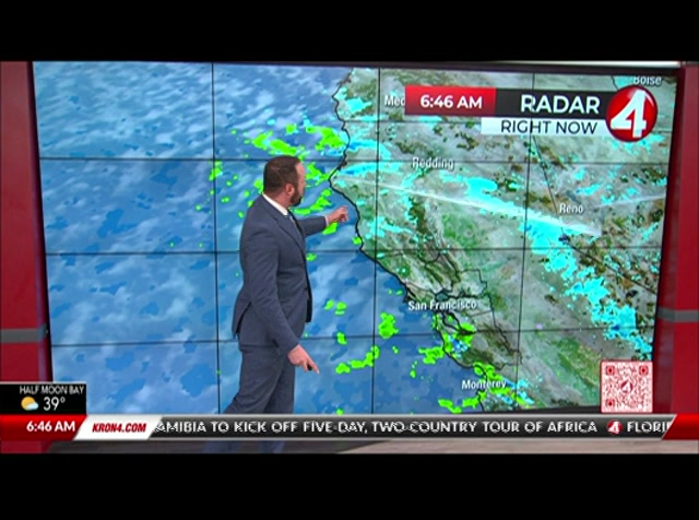
mountains, but east bay hills. that's going to continue through tuesday. so we are tracking this atmospheric river tapping into a plume of subtropical moisture. going to give us widespread rain. so right now we're going to start to see that drying trend. still seeing those showers out there in the south bay. but for the rest of the bay area, we're already drying out. that's going to continue throughout tonight. but the bulk of that river first going to ride for those of you in the north bay by monday morning. this is going to have a negative impact on your morning commute. so plan ahead and drive safely could see thunderstorms, hail and gusty winds throughout your monday morning commute with some scattered showers by monday afternoon with the 3rd round of rain arriving tuesday through wednesday. so we could see anywhere from about 3 quarters of an inch of rain or less doubled those amounts through wednesday. more my full forecast and a look at your sierra outlook in just a few minutes. back to dan and noelle. >> th
mountains, but east bay hills. that's going to continue through tuesday. so we are tracking this atmospheric river tapping into a plume of subtropical moisture. going to give us widespread rain. so right now we're going to start to see that drying trend. still seeing those showers out there in the south bay. but for the rest of the bay area, we're already drying out. that's going to continue throughout tonight. but the bulk of that river first going to ride for those of you in the north bay by...
0
0.0
Feb 24, 2023
02/23
by
KPIX
tv
eye 0
favorite 0
quote 0
in the east bay hills, it is just scattered showers. but you see a little blue showing up right there. snow has gotten down as low as the ridge tops there, which means grizzly peak at 1800 feet has had beautiful snow all morning. we have been looking at that as well with our live shots. justin andrews has been there to share it with us all morning long. it really has been very cool to look at. and the north bay has had its fair share of snow. and a that is higher than 1000 feet will have a light dusting of snow this morning. if you are not getting snowed on, you will be able to get to see snow wherever you are in the bay area. scattered showers staying with us this afternoon. there is an uptick in snow as we go through late afternoon. watch this wave. saturday morning gets us to the predawn hours of saturday. more snow in the north bay mountains. by saturday afternoon, it will come to an end. then there is another system coming our way. another storm comes in for the second half of sunday. we will look at that in our seven-day forecast.
in the east bay hills, it is just scattered showers. but you see a little blue showing up right there. snow has gotten down as low as the ridge tops there, which means grizzly peak at 1800 feet has had beautiful snow all morning. we have been looking at that as well with our live shots. justin andrews has been there to share it with us all morning long. it really has been very cool to look at. and the north bay has had its fair share of snow. and a that is higher than 1000 feet will have a...
0
0.0
Feb 23, 2023
02/23
by
KRON
tv
eye 0
favorite 0
quote 0
mountains, east bay hills. and even a chance of some flurries right there around twin peaks about davidson in san francisco itself. now as far as future casco spotty showers will continue through the day today. really picking up activity into the evening tonight, though, this is 07:00pm, much more widespread rainfall. and you see those areas of yellow and orange pockets of heavy rain pushing through as well. maybe even a roll of thunder, too. and snow falling to increasingly low elevations as we make our way on into tomorrow morning. so quite the active next. 24 hours. rainfall between here into early next week of around an inch and then out up on top of that, another inch or 2 into next week as we see even more rainfall, winds calmer than they had been. but we will be seeing them picking up into the evening tonight. so do watch for that. daytime highs today in the upper 40's to low 50's and looking ahead at our next 7 days, we're going to see temperatures remaining pretty steady. those upper 40's to low 50's a
mountains, east bay hills. and even a chance of some flurries right there around twin peaks about davidson in san francisco itself. now as far as future casco spotty showers will continue through the day today. really picking up activity into the evening tonight, though, this is 07:00pm, much more widespread rainfall. and you see those areas of yellow and orange pockets of heavy rain pushing through as well. maybe even a roll of thunder, too. and snow falling to increasingly low elevations as...
0
0.0
Feb 23, 2023
02/23
by
KRON
tv
eye 0
favorite 0
quote 0
now, the east bay hills right now are looking pretty good. we don't have any fog out there, but we do have these spotty showers moving across the bay area. it's solid snowfall for the north coast as well as the sierra nevada in a mix of snow and rain for the bay area. snow up there widespread across the santa cruz mountains as well as up into the mount hamilton area above san jose. you're also seeing it on mission pekin note. blow earlier today saw some flurries on mount tam and i would not be at all surprised if this morning we saw some flurries around santa rosa northward from there. we're under winter storm warnings for the north bay mountains, east bay hills and mountains as well as the santa cruz in diablo range is of the south bay. these will take effect later on today into tonight. tonight into tomorrow morning will be our best chance of snow falling as low as areas like twin peaks in san francisco and the east bay hills. we also have frost advisories and freeze warnings in effect through the day. now, futurecast of snowfall total show
now, the east bay hills right now are looking pretty good. we don't have any fog out there, but we do have these spotty showers moving across the bay area. it's solid snowfall for the north coast as well as the sierra nevada in a mix of snow and rain for the bay area. snow up there widespread across the santa cruz mountains as well as up into the mount hamilton area above san jose. you're also seeing it on mission pekin note. blow earlier today saw some flurries on mount tam and i would not be...
0
0.0
Feb 23, 2023
02/23
by
KPIX
tv
eye 0
favorite 0
quote 0
even higher amounts around the edges of the bay area, maybe some accumulation around the east bay hills. if you travel on california 24 through the caldecott tunnel, there will be a layer of flakes on the ground, but higher amounts through the north bay mountains as well. so all the highways through the higher elevations, you want to avoid those. for most of the bay area, anywhere from a half inch to over an inch of rain. a lot of that aimed at the southern end of the bay area , just where the second round of moisture will be aimed on friday night into early saturday. it will also be called. temperatures tonight dropping down into the 30s areawide. even downtown san francisco dipping down into the upper 30s for low temperatures. you want to get your dogs out for a walk tomorrow, pickle and lilac won't have a lot of sunshine to bask in tomorrow, but still, where the pups out tomorrow. it will still be cold and breezy. temperatures will not warm up very much. only upper 40s to around 50 degrees for highs thursday afternoon. our temperatures don't warm up very much through the entirety of
even higher amounts around the edges of the bay area, maybe some accumulation around the east bay hills. if you travel on california 24 through the caldecott tunnel, there will be a layer of flakes on the ground, but higher amounts through the north bay mountains as well. so all the highways through the higher elevations, you want to avoid those. for most of the bay area, anywhere from a half inch to over an inch of rain. a lot of that aimed at the southern end of the bay area , just where the...
0
0.0
Feb 27, 2023
02/23
by
KGO
tv
eye 0
favorite 0
quote 0
bay hills and santa clara hills. so this winter weather advisory is in effect in the east bay and southbay hills from 10:00 p.m. tomorrow until 4:00 p.m. tuesday. more on the weather coming up this week in just a moment. spencer, thank you. crews are working to restore power after a week of dry wet weather brought down trees and power lines. at last check, more than 4000 customers were without electricity. across the state, 120,000 people lost electricity today. contra costa county residents impacted by the series of winter storms in december and january, still have time to apply for federal assistance. in disaster recovery center opened today at the civic center. residents can apply in person from 8:00 a.m. to 6:00 p.m.. the center will be open through february, and it will then move to community presbyterian church in pittsburgh. don't forget, you can always track of weather conditions and access the same live doppler 7 that our own uses, anytime you want. you can find it on demand on the abc7 bay area app. a speci
bay hills and santa clara hills. so this winter weather advisory is in effect in the east bay and southbay hills from 10:00 p.m. tomorrow until 4:00 p.m. tuesday. more on the weather coming up this week in just a moment. spencer, thank you. crews are working to restore power after a week of dry wet weather brought down trees and power lines. at last check, more than 4000 customers were without electricity. across the state, 120,000 people lost electricity today. contra costa county residents...
12
12
Feb 17, 2023
02/23
by
KRON
tv
eye 12
favorite 0
quote 0
right now, the east bay hills camera showing you the clear skies. we have not looking at a foggy start, but another cold start. we're in the 30's for areas like san mateo, redwood city, down through mountain view, fremont on inland over to livermore and dublin and even half moon bay at the coast. also up in the north bay petaluma and santa rosa down at 35 degrees right now. sonoma all the way down to 33 degrees. so definitely a chilly start. not quite cold enough for frost advisories and freeze warnings, though, breezy out of the delta as well as at the coastline. most of us are on the calmer side of things this morning. we do see some offshore showers resulting in just a few sprinkles right along the coastline in sonoma county on up into mendocino county. these are going to skirt right past the bay area, though. so we're not really looking at the potential in the bay area today. that system just traveling too far to the west for us. so what we've got is increasingly clear skies by the afternoon, mostly sunny, nice conditions. daytime highs pushing
right now, the east bay hills camera showing you the clear skies. we have not looking at a foggy start, but another cold start. we're in the 30's for areas like san mateo, redwood city, down through mountain view, fremont on inland over to livermore and dublin and even half moon bay at the coast. also up in the north bay petaluma and santa rosa down at 35 degrees right now. sonoma all the way down to 33 degrees. so definitely a chilly start. not quite cold enough for frost advisories and freeze...
0
0.0
Feb 23, 2023
02/23
by
KRON
tv
eye 0
favorite 0
quote 0
mountains, the east bay hills in the north bay hills. tonight's the night that we're going to see snow levels low drop the lowest frost advisories and freeze warnings in expected it. and in effect, as we speak right now and snow level tonight getting even lower. keep your eye out for some flurries tomorrow morning. if you're up around mount hamilton, multiple feet of snowfall, multiple inches for the north bay and east bay mountains. now, pockets of rainfall continue on and off through the day today. we will see snow remaining for the most part above 1000 feet today. heavy pockets of rain fall tonight and snow level dropping down to in some cases as low as 8, even 500 feet in elevation. that's when areas like the twin peaks may see a few flurries this evening. as far as rain goes, we've got another inch of it this week and another one to 2 inches on top of that into next week. so a pretty busy forecast. winds are going to be calmer today than they have been but still gusting 20 to 30 miles per hour. and as far as daytime highs go only in
mountains, the east bay hills in the north bay hills. tonight's the night that we're going to see snow levels low drop the lowest frost advisories and freeze warnings in expected it. and in effect, as we speak right now and snow level tonight getting even lower. keep your eye out for some flurries tomorrow morning. if you're up around mount hamilton, multiple feet of snowfall, multiple inches for the north bay and east bay mountains. now, pockets of rainfall continue on and off through the day...
0
0.0
Feb 27, 2023
02/23
by
KRON
tv
eye 0
favorite 0
quote 0
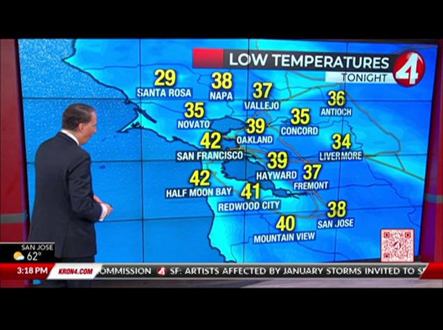
east bay hills, including eastern santa clara hills as well. going to be under a winter storm advisory. and we're going to see severe weather with the threat of hail if any pop-up thunderstorms do form gusty winds 50 miles per hour or less impacting your monday morning and monday afternoon commute. so just keep that in mind by monday night. that second storm going to exit only to be replaced by 3rd storm tuesday morning through wednesday morning. so we're going to see at least an inch of additional rain for the bay area from coast to valleys. right now, we're tracking a very dry, clear and cool outlook. half moon cooling down to 39 degrees with fairfax currently in the mid 30's at 34 degrees in petaluma dipping into the upper 30's overnight lows tonight below freezing for santa rosa. 31 degrees with widespread mid to upper 30's for the rest of our inland valleys. high temperatures tomorrow, very similar to today upper 40's to low 50's when we should be in the low to mid 60's 5 to 15 degrees below average. getting a little bit of a break from th
east bay hills, including eastern santa clara hills as well. going to be under a winter storm advisory. and we're going to see severe weather with the threat of hail if any pop-up thunderstorms do form gusty winds 50 miles per hour or less impacting your monday morning and monday afternoon commute. so just keep that in mind by monday night. that second storm going to exit only to be replaced by 3rd storm tuesday morning through wednesday morning. so we're going to see at least an inch of...
0
0.0
Feb 24, 2023
02/23
by
KRON
tv
eye 0
favorite 0
quote 0
you can see that transition zone there in the east bay hills. i'm also looking really closely at i-80 once you get north east of la home on a pass, fairfield and vacaville as you drive through the hills there. little spot of snowfall that you're going to be traversing through right there on i-80, as well as up 505 north of vacaville through winters on up towards highway 5. 101 has been really rough this morning. it's a mixture of rain. we had some sleet up there as well, which has resulted in really slick conditions of both marin and sonoma counties. you go north of santa rosa, north of healdsburg. that's where you're seeing snowpack conditions on 1, cloverdale reports of people being stuck in the snow up there during overnight hours because of just how heavy that snow really was coming down there. as for most of the bay area, it's rainfall right now. this is really inundated. most of our bridges, the richmond center fell bridge as well as the bay bridge is. you can see in the midst of some of those heavier showers right now, including san franc
you can see that transition zone there in the east bay hills. i'm also looking really closely at i-80 once you get north east of la home on a pass, fairfield and vacaville as you drive through the hills there. little spot of snowfall that you're going to be traversing through right there on i-80, as well as up 505 north of vacaville through winters on up towards highway 5. 101 has been really rough this morning. it's a mixture of rain. we had some sleet up there as well, which has resulted in...
0
0.0
Feb 23, 2023
02/23
by
KRON
tv
eye 0
favorite 0
quote 0
the north bay hills, east bay hills and then the santa cruz and diablo range is of the south bay. snow levels expected to fall even further. and a winter weather advisory for parts of this year to we have winter. we have frost advisories and freeze warnings. i should say for the rest of the bay area because temperatures are getting so cold out there dropping below freezing for parts of the north bay. watch tonight for some snowfall in areas like santa rosa on up into northern sonoma county. even a few flurries possibly sticking at the top of twin peaks. and then multiple feet of snow at the top about hamilton tonight. as for our daytime, we can expect hours today to bring spots of sunshine. also, some areas of rain and even snow fall at higher elevations. the spotty showers will become more and more widespread into the evening and heavy pockets of rain fall on into the close of the day today. areas like the towards midnight tonight seeing some heavy out down. bur a areas of heavy rainfall pushing in and then snowfall up in the north bay becoming most likely on into early morning h
the north bay hills, east bay hills and then the santa cruz and diablo range is of the south bay. snow levels expected to fall even further. and a winter weather advisory for parts of this year to we have winter. we have frost advisories and freeze warnings. i should say for the rest of the bay area because temperatures are getting so cold out there dropping below freezing for parts of the north bay. watch tonight for some snowfall in areas like santa rosa on up into northern sonoma county....
0
0.0
Feb 27, 2023
02/23
by
KRON
tv
eye 0
favorite 0
quote 0
for the east bay hills, including eastern santa clara hills. you're going to be under that winter weather advisory starting at 10 o'clock monday. both set to expire by tuenday afternoon with elevations above 3,000 feet, getting anywhere from 5 to 10 inches of snow. with that slushy snow and rain mixture at the lower level. so let's take a look at these upcoming storms. the second round that's going to arrive early monday morning, lasting through monday night. and we're going to see for hills and mountains a little bit more than an inch of rain for the bay area. we're going to get anywhere from a quarter of an inch to three-quarters of an inch of rain. >> slightly lesser amounts with story number 3 on tuesday through wednesday, just about half an inch of rain or less. but the same amount for local hills and mountains. but this is going to be severe storms colder, unstable air mass making its way. that's why could see gusts upwards of 50 miles per hour with hail and even thunderstorms. if any do form. so let's take a look at radar for it. very dr
for the east bay hills, including eastern santa clara hills. you're going to be under that winter weather advisory starting at 10 o'clock monday. both set to expire by tuenday afternoon with elevations above 3,000 feet, getting anywhere from 5 to 10 inches of snow. with that slushy snow and rain mixture at the lower level. so let's take a look at these upcoming storms. the second round that's going to arrive early monday morning, lasting through monday night. and we're going to see for hills...
0
0.0
Feb 13, 2023
02/23
by
KRON
tv
eye 0
favorite 0
quote 0
bay hills. maybe question mark with all of that and it's gone. you can see very moisture starved a lot with it. we lose the winds for tomorrow night. clear skies and temperatures kind of go into a little bit of free fall. let's get to those winds now. they're helping us out tonight. activision will notice winds into the 20's, even some 30's going on here. that's weather. wind advisory has been posted along the a strip along the coast. solano county looks like some offshore winds hanging together for late tonight into tomorrow morning. even as late as about wednesday morning and have more on your forecast. what these cold temperatures coming your way in a bit. justine. >> dave, thanks so much. california's sequoia national park is now back open. recent storms forced the area along with generals highway to close because of severe road damage. the reopening allows the access to the giant forest museum, the general sherman tree and the woolverton snow play area. if you are headed to the park, you ca
bay hills. maybe question mark with all of that and it's gone. you can see very moisture starved a lot with it. we lose the winds for tomorrow night. clear skies and temperatures kind of go into a little bit of free fall. let's get to those winds now. they're helping us out tonight. activision will notice winds into the 20's, even some 30's going on here. that's weather. wind advisory has been posted along the a strip along the coast. solano county looks like some offshore winds hanging...
0
0.0
Feb 19, 2023
02/23
by
KGO
tv
eye 0
favorite 0
quote 0
there is a view from east bay hills. a colorful western sky. just enough clouds to give the pre-and sun -- pre-sunset sky this glow. low 60's. palo alto, san jose, santa clara at 52. golden gate a little bit cloudier. a pleasant afternoon. 64 degrees up north. a c 60 in concord. from the rooftop camera, looking across the embarcadero, forecast headlines. mild days and chilly mornings. turning windy and colder tuesday and wednesday. a wet, unsettled pattern of weather. tonight, mainly clear skies. high clouds passing over. it will be pretty chilly. in the north bay, 33 in santa rosa. over in the inland east bay, 36. livermore, 38. similar range of temperatures, mid to upper 30's in san jose. right around the bay shoreline. highs tomorrow, 60 in half moon bay. nice and mild. 65, 66 around the bay shoreline. upper 60's in many inland areas. 70 degrees in santa rosa. the forecast starting noon monday shows the wet weather system moving in our direction late tuesday night. wednesday, we get cold showers. maybe even a mix of rain and high elevations.
there is a view from east bay hills. a colorful western sky. just enough clouds to give the pre-and sun -- pre-sunset sky this glow. low 60's. palo alto, san jose, santa clara at 52. golden gate a little bit cloudier. a pleasant afternoon. 64 degrees up north. a c 60 in concord. from the rooftop camera, looking across the embarcadero, forecast headlines. mild days and chilly mornings. turning windy and colder tuesday and wednesday. a wet, unsettled pattern of weather. tonight, mainly clear...
0
0.0
Feb 27, 2023
02/23
by
KRON
tv
eye 0
favorite 0
quote 0
and as you could see for our east bay hills, including the mount diablo range, getting that mixture of rain and snow showers. but it's going to be this second stronger storm out in the pacific northwest. that's going to bring us widespread rain and also some pretty severe weather as well. in addition to snow for the north bay mountains monday morning. we're also going to see pop-up thunderstorms, hail and gusty winds 50 miles per hour or less making for a dangerous monday morning commute. calmer conditions by monday afternoon. but don't put away your umbrella just yet, because as you can we're still tracking some scattered showers with round 3 arriving tuesday morning. more. my full forecast coming up in just a few minutes. stand and walk back to you. >> despite the rain, a big turnout today in san jose and supportive to street food vendors who were attacked in recent weeks. all the money from today's cookout will go directly to the 2 men. it comes as one of the attackers is apologizing for their actions. kron 4 sarah stinson reports. >> rain or shine people really showed up in san jos
and as you could see for our east bay hills, including the mount diablo range, getting that mixture of rain and snow showers. but it's going to be this second stronger storm out in the pacific northwest. that's going to bring us widespread rain and also some pretty severe weather as well. in addition to snow for the north bay mountains monday morning. we're also going to see pop-up thunderstorms, hail and gusty winds 50 miles per hour or less making for a dangerous monday morning commute....
10
10.0
Feb 17, 2023
02/23
by
KRON
tv
eye 10
favorite 0
quote 0
right now, the east bay hills camera showing you the clear skies. we have not looking at a foggy start, but another cold start. we're in the 30's for areas like san mateo, redwood city, down through mountain view, fremont on inland over to livermore and dublin and even half moon bay at the coast. also up in the north bay petaluma and santa rosa down at 35 degrees right now. sonoma all the way down to 33 degrees. so definitely a chilly start. not quite cold enough for frost advisories and freeze warnings, though, breezy out of the delta as well as at the coastline. most of us are on the calmer side of things this morning. we do see some offshore showers resulting in just a few sprinkles right along the coastline in sonoma county on up into mendocino county. these are going to skirt right past the bay area, though. so we're not really looking at the potential in the bay area today.
right now, the east bay hills camera showing you the clear skies. we have not looking at a foggy start, but another cold start. we're in the 30's for areas like san mateo, redwood city, down through mountain view, fremont on inland over to livermore and dublin and even half moon bay at the coast. also up in the north bay petaluma and santa rosa down at 35 degrees right now. sonoma all the way down to 33 degrees. so definitely a chilly start. not quite cold enough for frost advisories and freeze...
0
0.0
Feb 24, 2023
02/23
by
KRON
tv
eye 0
favorite 0
quote 0
winter storm warning still in effect above 1000 feet for the bay area, north bay hills, east bay hills in the south bay mountains, all still under them. freeze warnings and frost advisories for another hour until 09:00am this morning with temperatures still in the 30's right now, snow accumulation does stay mostly in upper elevations until you get to northern sonoma and napa counties, then you get up into lake and mendocino counties and it is just winter in full force up there. nothing but snowfall resulting in some road closures that direction. now, futurecast pockets of rainfall and snow for that matter through the rest of the morning, we gradually see more and more sunshine. the later in the day you get by the afternoon. you do have a good dose of sun and between a few of those darker clouds. tomorrow we start the day with a few showers and then dry out consistently the rest of your saturday before resurgence of rainfall into sunday monday and tuesday of next week. we do have another inch of rainfall to be expected today tomorrow morning into sunday and early monday, adding even mor
winter storm warning still in effect above 1000 feet for the bay area, north bay hills, east bay hills in the south bay mountains, all still under them. freeze warnings and frost advisories for another hour until 09:00am this morning with temperatures still in the 30's right now, snow accumulation does stay mostly in upper elevations until you get to northern sonoma and napa counties, then you get up into lake and mendocino counties and it is just winter in full force up there. nothing but...
0
0.0
Feb 27, 2023
02/23
by
KRON
tv
eye 0
favorite 0
quote 0
those of you that are leaving early, you're getting the easy end of the east bay hills camera looking nice and clear as does the rest of the bay area. if you look to our north, this is what we're looking at making its way our direction, solid snow falling or upper elevations of the north coast in rain towards sea level. still holding on to that snow up in the sierra nevada and showers still for southern california out into the central valley to now timing this out for us. we will see dry conditions the next couple of hours. so if you are early birds, you're definitely getting easier commute this morning. those waiting to later are definitely going to be seeing the ref or staff 07:30am, a few showers on the peninsula after that, we'll see an increase in rainfall. this is the line of rain i'm really looking at right here. that makes its way into the north bay, starting at 08:00am towards 09:00am for the rest of us. this is a head, the line of rainfall. so you're not going to miss it. packing a punch with strong winds, heavy rain, potentially even some hail embedded in there sweeps throu
those of you that are leaving early, you're getting the easy end of the east bay hills camera looking nice and clear as does the rest of the bay area. if you look to our north, this is what we're looking at making its way our direction, solid snow falling or upper elevations of the north coast in rain towards sea level. still holding on to that snow up in the sierra nevada and showers still for southern california out into the central valley to now timing this out for us. we will see dry...
39
39
Feb 18, 2023
02/23
by
KRON
tv
eye 39
favorite 0
quote 0
little dusting along the east bay hills. this is probably our last shot of said he had with certainly this cold system we're looking at storm tracker 4. this is where it's going to come from up here in the gulf of alaska. right now it's being blocked. it's not really well developed that will come later. 60 san francisco about 63 for oakland. 66 san jose. lot of middle to lower 60's to be had for high temperatures for today. again, we're going up that tomorrow. but boy, some really winter weather going on free into next week. we'll have more on those details coming up in a bit, stephanie. all right, dave, thank you. >> the suspect in last week's deadly explosion at a home in san francisco will be released on house arrest. he appeared back in court friday and faces a string of felony charges. kron four's gayle ong reports. >> at a friday morning arraignment, the judge ruled 53 year-old darron price was criminally careless about last week's house explosion in san francisco's outer sunset district. but does not need to be detain
little dusting along the east bay hills. this is probably our last shot of said he had with certainly this cold system we're looking at storm tracker 4. this is where it's going to come from up here in the gulf of alaska. right now it's being blocked. it's not really well developed that will come later. 60 san francisco about 63 for oakland. 66 san jose. lot of middle to lower 60's to be had for high temperatures for today. again, we're going up that tomorrow. but boy, some really winter...
0
0.0
Feb 14, 2023
02/23
by
KRON
tv
eye 0
favorite 0
quote 0
. >> from the east bay hills looking down into the bay yesterday. at this point, you're seeing that dense fog just settling right in there today. much different. so it is clear, but it is really windy. and that is contributing to a very brisk feel. even if you are in the 40's right now. yeah, feel colder than that. when you factor in windchill san mateo timber on santa rosa at 41. all livermore to dublin, vallejo and napa among spots in the upper 30's. take a look at some of these winds. half moon bay been seeing winds gusting regularly into a 40 mile per hour range. sandra fell petaluma even san francisco and oakland seeing winds gusting up to a 20 to 30 mile per hour range and that contributes to this very brisk feel this morning. you're really going to feel those winds on your bridges as well as on mountain passes as you make the commute into work. now i'm going to be talking a colder afternoon for your valentine's day. all those details still to come in your forecast rain. all right, john, thanks for that. let's check on those bridges. 14 minute
. >> from the east bay hills looking down into the bay yesterday. at this point, you're seeing that dense fog just settling right in there today. much different. so it is clear, but it is really windy. and that is contributing to a very brisk feel. even if you are in the 40's right now. yeah, feel colder than that. when you factor in windchill san mateo timber on santa rosa at 41. all livermore to dublin, vallejo and napa among spots in the upper 30's. take a look at some of these winds....
0
0.0
Feb 27, 2023
02/23
by
KRON
tv
eye 0
favorite 0
quote 0
bay hills looking nice and clear. we're tracking the showers to our north right now. rainfall at sea level snow for those upper elevations along the north coast. and we are also seeing snow holding up in the sierra nevada. we are under some winter storm warnings up there all the way through midweek for the bay area. as i mentioned, we look at a return of rainfall later this morning. a few sprinkles around 07:00am on the peninsula. but really after that 7, 08:00am, to 09:00am this heavy line of rain pushes through. this is 9.30, right here in heavy rain pushing through the bay area along with it. some really strong winds that make their way right through the bay pushing through. and after that, the storm doors open pockets of rain, even a roll of thunder or 2 possible come the afternoon in between these pockets of heavy rainfall. you will be seeing some times of sunshine in there. so it's all about just capitalizing on the moment. if the dog needs to go outside, see that sun, get out there, enjoy it. but don't expect i
bay hills looking nice and clear. we're tracking the showers to our north right now. rainfall at sea level snow for those upper elevations along the north coast. and we are also seeing snow holding up in the sierra nevada. we are under some winter storm warnings up there all the way through midweek for the bay area. as i mentioned, we look at a return of rainfall later this morning. a few sprinkles around 07:00am on the peninsula. but really after that 7, 08:00am, to 09:00am this heavy line of...
0
0.0
Feb 27, 2023
02/23
by
KNTV
tv
eye 0
favorite 0
quote 0
east bay hills, diablo rain and north bay, monday and tuesday. notice the futurecast through tuesday, still those opportunities with showers. you see the blue and the pink, indication we could still see snow showers in the inland mountains through the middle part of the week. things will dry out thursday into friday. we could see the third chance for low snow coming in next weekend. there you go. new months, but it's the same forecast with these cold temperatures. warmest, driest part of the week will be thursday and friday. we say warmest, that's mid-50s. >> yeah. >> that's not very warm. and next weekend a chance of seeing low snow. sierra, by the way, could see 6 to 7 feet of snow just this week. that sierra snowpack continues to get super sized. if the blizzard warning, avoid travel there through wednesday. >> that is intense. thank you. >>> coming up, more relief on the way for south bay small business owners. what you need to know about the new funds that are available. >>> in the south bay, san jose small businesses can soon apply for covi
east bay hills, diablo rain and north bay, monday and tuesday. notice the futurecast through tuesday, still those opportunities with showers. you see the blue and the pink, indication we could still see snow showers in the inland mountains through the middle part of the week. things will dry out thursday into friday. we could see the third chance for low snow coming in next weekend. there you go. new months, but it's the same forecast with these cold temperatures. warmest, driest part of the...
0
0.0
Feb 20, 2023
02/23
by
KPIX
tv
eye 0
favorite 0
quote 0
bay hills. that would come on wednesday and thursday. look how cold it's going to be. morning lows for the north bay valleys are going down in the up tores on thursday and friday. so as we look at the 7 day forecast, yes, there is a chance of rain that shows up here on wednesday, thursday and friday. but it's the wind and the cold that's probably the bigger aspect of us and you can see itlooks the same for the microclimates. vern, over to you. >> all right, straight ahead in sports -- >>> regulation play? ha ha. not enough for a couple of sunday sports items and i have two words for you. spring-training. oh, yeah. it's here. and now. for the a's and for a one-time athletic turned giant. ♪ ♪ before the xfinity 10g network we didn't have internet that let us play all at once. every device? in every room? why are you up here? with speeds like this, i can't even dream of what he'll be able to do. get xfinity internet for just $25 a month with no annual contract during our limited time launch cel
bay hills. that would come on wednesday and thursday. look how cold it's going to be. morning lows for the north bay valleys are going down in the up tores on thursday and friday. so as we look at the 7 day forecast, yes, there is a chance of rain that shows up here on wednesday, thursday and friday. but it's the wind and the cold that's probably the bigger aspect of us and you can see itlooks the same for the microclimates. vern, over to you. >> all right, straight ahead in sports --...
0
0.0
Feb 21, 2023
02/23
by
KRON
tv
eye 0
favorite 0
quote 0
so you want to keep that in mind. >> here's a live picture from the east bay hills. you can see cloudy skies and this tuesday morning and we do have some high winds in the forecast. that's going to start today in this afternoon around 01:00pm. and then that's going to go into effect until wednesday tomorrow. 01:00pm for the entire bay area. so we're talking wind gusts of 25 to 35 miles per hour and gusts up to 55 miles per hour in the higher elevations. so this is really the start of our active weather pattern we're seeing from that cold front moving over the region, stormtracker for it, not showing much activity today, but futurecast for changes, especially when you have into wednesday. that's when we're going to see some showers that will be impacting the coast and then the showers do continue until thursday and even friday. and you may even notice some of that blue and pink and we're seeing some snow on the mountain tops and is stings a line. you could see some snowflakes on the lower valleys. yeah, you want to prepare for wednesday, thursday and friday. as for th
so you want to keep that in mind. >> here's a live picture from the east bay hills. you can see cloudy skies and this tuesday morning and we do have some high winds in the forecast. that's going to start today in this afternoon around 01:00pm. and then that's going to go into effect until wednesday tomorrow. 01:00pm for the entire bay area. so we're talking wind gusts of 25 to 35 miles per hour and gusts up to 55 miles per hour in the higher elevations. so this is really the start of our...
0
0.0
Feb 24, 2023
02/23
by
KPIX
tv
eye 0
favorite 0
quote 0
however for the rest of the bay area, the east bay hills, the diablo range, santa cruz mountains, the snow level will continue dropping all the way down to the 1200-foot level. more moisture offshore. but this should be pushing through as we get toward the peak of rush hour tomorrow morning. more of a break in the action. plan on a slow commute and treacherous travel conditions in the north bay mountains and the santa cruz mountains. highway 9, highway 17. highway 35. all those will be sloppy. and more off and on showers through the day tomorrow. a little break in the action developing before showers back up toward us as we head into tomorrow night and early saturday. that shower activity will not last too long. we should be catching a break. here is the winter storm warning for all elevations above 1500 feet. that could drop all the way down to about 1200 feet. the amounts are going to vary wildly. on the in ra snowdiheavy wet sn the higher you go, several inches of accumulation will occur especially further above 2,000 or 3,000 feet. it will add up to half an inch to an inch out of
however for the rest of the bay area, the east bay hills, the diablo range, santa cruz mountains, the snow level will continue dropping all the way down to the 1200-foot level. more moisture offshore. but this should be pushing through as we get toward the peak of rush hour tomorrow morning. more of a break in the action. plan on a slow commute and treacherous travel conditions in the north bay mountains and the santa cruz mountains. highway 9, highway 17. highway 35. all those will be sloppy....
0
0.0
Feb 4, 2023
02/23
by
KRON
tv
eye 0
favorite 0
quote 0
looking for the east bay hills. you can see all the moisture in our skies already as we get ready for the weekend to we've got another storm system on the way. how about this? almost 3 quarters of inch of rain in santa rosa. timber on you had over half an inch of rain just under half an inch of rain in napa, half an inch of rain, even in downtown san francisco under half an inch of rain in oakland at 16, 100's in san jose. some of the mountain tops over 3 quarters of an inch of rain. and there is more to come. here's a look at that. storm moved through overnight this morning. moving on by and pushing eastward. so we're catching a little bit of a break on the backside of that right now. a lot of clouds continue to linger in our skies overnight tonight. and then tomorrow we've got another storm system on the way. in fact, they're kind of lined up now that storm really opened the door to a series of storms. the likely impact the bay area throughout the weekend and well into next week, too. all right. for tomorrow, you'
looking for the east bay hills. you can see all the moisture in our skies already as we get ready for the weekend to we've got another storm system on the way. how about this? almost 3 quarters of inch of rain in santa rosa. timber on you had over half an inch of rain just under half an inch of rain in napa, half an inch of rain, even in downtown san francisco under half an inch of rain in oakland at 16, 100's in san jose. some of the mountain tops over 3 quarters of an inch of rain. and there...
0
0.0
tv
eye 0
favorite 0
quote 0
frances: here is a live shot from the east bay hills, it is gorgeous right now. temperatures are chilly, dropping into the mid-30's, especially for parts of the north bay. here is a look at temperatures. i this afternoon, we will see warmer temperatures compared to yesterday. i will let you know what to expect after the break. ♪ it's time to bring balance to business travel. and discover the equilibrium that works for you. at national, you're in control. skip the counter, choose any car in the aisle... and manage your rental right from the app. so you can mix work... with leisure. or leisure... with work. giving you the control to find the perfect balance. go national. go like a pro. business can happen anytime, anywhere. so help yours thrive and stay connected with the comcast business complete connectivity solution. it's the largest, fastest, reliable network. advanced gig speed wifi. and cyberthreat protection. starting at just $49.99 a month. plus, you can save up to 60% a year when you add comcast business mobile. or, ask how to get up to a $750 prepaid ca
frances: here is a live shot from the east bay hills, it is gorgeous right now. temperatures are chilly, dropping into the mid-30's, especially for parts of the north bay. here is a look at temperatures. i this afternoon, we will see warmer temperatures compared to yesterday. i will let you know what to expect after the break. ♪ it's time to bring balance to business travel. and discover the equilibrium that works for you. at national, you're in control. skip the counter, choose any car in...
0
0.0
Feb 25, 2023
02/23
by
KGO
tv
eye 0
favorite 0
quote 0
it is a bay area snow day, a rare storm in the valley, east bay hills, and the santa cruz mountains. those cold temperatures are here to stay. good evening. i'm ama daetz. dan: and i'm dan ashley. people are welcoming the snow with a sense of wonder. obviously the coal did not keep them away. ama: the big question is, how long will this last? let's get right to abc 7 meteorologist sandhya patel. sandhya: no, we are not looking at blue canyon, not looking at lake tahoe, this is mount tam. if you hike up there, this is something you do not see all the time. this is definitely a snow-covered ground. taking a look at live doppler 7 a while it is quiet at this hour, there are a few showers showing up. as we pan around other parts of the bay area, mount hamilton has been seeing these snow showers over the last few hours, and then right over the ultima pass, same thing with the oakwood, brentwood area, watch out, there are still some slippery spots. widening out the picture, this is a light level one storm. the area of the coast will pass along the coast. we go hour-by-hour, as big as a lit
it is a bay area snow day, a rare storm in the valley, east bay hills, and the santa cruz mountains. those cold temperatures are here to stay. good evening. i'm ama daetz. dan: and i'm dan ashley. people are welcoming the snow with a sense of wonder. obviously the coal did not keep them away. ama: the big question is, how long will this last? let's get right to abc 7 meteorologist sandhya patel. sandhya: no, we are not looking at blue canyon, not looking at lake tahoe, this is mount tam. if you...
0
0.0
Feb 13, 2023
02/23
by
KRON
tv
eye 0
favorite 0
quote 0
so therefore, you might have a little flakes tossed about around the east bay hills, just a touch, although there will be some snow up in the mountains and then cold. after all of that, as we're going to spear some chilly morning lows. that's where you're really going to feel. nice bite in the air. remind you that. yes, february is a winter months to come. those onshore winds do from the northwest, as you will notice, really building quite a bit along the coastal strip. but you can feel a little solano county, after all said and done coming in from the northerly direction. highs will go with around the mid 60's at best lower to middle 60's at that. here's your seven-day forecast in the big drop we're talking about 52. that's on highs for an isolated shower. we'll see some lower 30's there for the next couple of days with 40's of the coast. well. dave, thank you. >> take a look at this. a 6 month-old puppy jumped out of a car window onto a busy freeway in la county. here's the video. the puppy makes a miracle landing. there he goes. the dangerous close call happened in woodland hills. the he
so therefore, you might have a little flakes tossed about around the east bay hills, just a touch, although there will be some snow up in the mountains and then cold. after all of that, as we're going to spear some chilly morning lows. that's where you're really going to feel. nice bite in the air. remind you that. yes, february is a winter months to come. those onshore winds do from the northwest, as you will notice, really building quite a bit along the coastal strip. but you can feel a...
0
0.0
Feb 28, 2023
02/23
by
KRON
tv
eye 0
favorite 0
quote 0
i mentioned to the east bay hills, including mount diablo, matt hamilton mission. pete, as well as up into the north bay mountains. we do have a winter storm warning still for lake county northward up into portions of mendo
i mentioned to the east bay hills, including mount diablo, matt hamilton mission. pete, as well as up into the north bay mountains. we do have a winter storm warning still for lake county northward up into portions of mendo
0
0.0
Feb 16, 2023
02/23
by
KGO
tv
eye 0
favorite 0
quote 0
you see it is across the bay from the east bay hills camera. it was chilly this morning. 29 at the santa rosa airport. 36 livermore. 35 napa. 38 san jose. 36 oakland. compared to 24 hours ago, everyone is warmer, which is nice. tomorrow morning will be cold, but i think we see an increase in temperatures as these high clouds move in our direction and insulate us lightly. for these and 50's. tower camera showing you these lovely views from san jose to the airport. some clouds near golden gate. here is a close-up view of the golden gate bridge and they look at the forecast headlines. cold tonight. areas of frost. mostly cold. a milder pattern. inland valleys tomorrow morning and hills under a freeze warning. areas in blue under a frost advisory. 2:00 a.m. to 9:00 a.m. bring in pets, protect plants, and don't forget to protect outdoor pipes because temperatures will be in the low to mid 30's and you could see some damage. 7:00. 40's and 50's. temperatures coming down. cloud cover increasing. low to mid 30's for inland valleys. below freezing in fa
you see it is across the bay from the east bay hills camera. it was chilly this morning. 29 at the santa rosa airport. 36 livermore. 35 napa. 38 san jose. 36 oakland. compared to 24 hours ago, everyone is warmer, which is nice. tomorrow morning will be cold, but i think we see an increase in temperatures as these high clouds move in our direction and insulate us lightly. for these and 50's. tower camera showing you these lovely views from san jose to the airport. some clouds near golden gate....
0
0.0
Feb 1, 2023
02/23
by
KRON
tv
eye 0
favorite 0
quote 0
bay hills. and so tonight they're going to see a mostly clear skies. again, chilly temperatures, freezing numbers inland. and then tomorrow, mixed bag of sunshine and some clouds rolling on by and the temperatures still on the cool side. but a chance of rain return to the bay area on thursday night and into friday. another storm expected for the weekend. temperatures out the door right now to get chilly in spots in the 40's coastside. 49 now in livermore. 52 in san jose. 51 in san francisco. 49 and sonoma and 46 degrees in calistoga. we've got high pressure overhead, but a start to weaken a little bit. and you see the clouds begin to rule over the top of that ridge will see more those high clouds throughout the day tomorrow. now behind that, though, things get a little more interesting. high pressure will start to weaken a little bit, but not tomorrow. we're going hold on one last day with some cool temperatures in the mixed bag of sunshine and a few clouds. but after that, now things begin to c
bay hills. and so tonight they're going to see a mostly clear skies. again, chilly temperatures, freezing numbers inland. and then tomorrow, mixed bag of sunshine and some clouds rolling on by and the temperatures still on the cool side. but a chance of rain return to the bay area on thursday night and into friday. another storm expected for the weekend. temperatures out the door right now to get chilly in spots in the 40's coastside. 49 now in livermore. 52 in san jose. 51 in san francisco. 49...
0
0.0
Feb 3, 2023
02/23
by
KRON
tv
eye 0
favorite 0
quote 0
your view out at the east bay hills looking pretty great at the moment. definitely a switch up from the dry, clear and cold conditions we've had earlier this week. it's mild and wet this morning. rainfall pushing into the bay area from the south and west and making its way to the north and east. so showers pushing this direction right here. widespread across the north bay pockets of heavier rain right around santa rosa right now. but especially so right here on the peninsula. this is specific it down to half moon bay highway one right there. really getting it. this energy is going to transfer a right over the peninsula mountains into the bay itself and on into the east bay. so we've got a lot going on ahead of us these next few hours. early risers, you are getting the worst of it this morning. the later in the morning. you wait. the more things should improve, but definitely watching ie come down these next several hours. so we keep you updated as we see more and more of it across the bay east bay roads getting wet. you're officially seeing rain on a tee
your view out at the east bay hills looking pretty great at the moment. definitely a switch up from the dry, clear and cold conditions we've had earlier this week. it's mild and wet this morning. rainfall pushing into the bay area from the south and west and making its way to the north and east. so showers pushing this direction right here. widespread across the north bay pockets of heavier rain right around santa rosa right now. but especially so right here on the peninsula. this is specific...
0
0.0
Feb 13, 2023
02/23
by
KRON
tv
eye 0
favorite 0
quote 0
. >> we're looking at some of conditions from the east bay hills into the bay. >> nice and clear at this perspective. but some fog forming down in the bay itself. so watch for some low visibility pockets. we do have visibility holding for most areas from oakland. hey, we're down to san jose though there is going to be the potential of some spots, a dense fog at times this morning. so do watch for that. otherwise it's cold. and it is also going to be a bit brisk. some strong winds, especially at the coastline, redwood city in dublin at 36 degrees. petaluma 37 santa rosa at 34 degrees now at the coastline is where we're going to strongest winds and where we also have high wind advisories taking ct
. >> we're looking at some of conditions from the east bay hills into the bay. >> nice and clear at this perspective. but some fog forming down in the bay itself. so watch for some low visibility pockets. we do have visibility holding for most areas from oakland. hey, we're down to san jose though there is going to be the potential of some spots, a dense fog at times this morning. so do watch for that. otherwise it's cold. and it is also going to be a bit brisk. some strong winds,...
0
0.0
Feb 5, 2023
02/23
by
KRON
tv
eye 0
favorite 0
quote 0
but our highest peaks north bay mountains in east bay hills. you could easily pick up about 2 inches of rain or less when it's all said and done until we start to dry out by early this upcoming week. more my full forecast in just a few minutes. back to you, dan. and all. >> all right, thanks a lot. in other news tonight, oakland police are investigating after a person's body was found lodged in a sewage home. the discovery was made early this morning near broadway and 3rd street in oakland. police are not releasing any other information at this time, including this person's identity, anyone with any information is asked to call oakland police. >> san jose police officers in the hospital tonight after being shot during a standoff as kron four's camila barco reports. this wasn't the officers first encounter with the suspect. >> san jose police officers encountered the suspect twice in the same night eventually led them to this neighborhood here in san jose. neighbors telling me they're surprised this happened in their backyard. >> a busy saturday
but our highest peaks north bay mountains in east bay hills. you could easily pick up about 2 inches of rain or less when it's all said and done until we start to dry out by early this upcoming week. more my full forecast in just a few minutes. back to you, dan. and all. >> all right, thanks a lot. in other news tonight, oakland police are investigating after a person's body was found lodged in a sewage home. the discovery was made early this morning near broadway and 3rd street in...
0
0.0
Feb 24, 2023
02/23
by
KRON
tv
eye 0
favorite 0
quote 0
east bay hills and the south bay mountains. all included in that. and still a few more minutes with freeze warnings and frost advisories across the bay area. temperatures still in the 30's as we speak. snowfall accumulation from this point forward should be fairly isolated to or upper elevations. that's where we're going to be continuing to see temperatures below freezing now, pockets of heavy rain and heavy snow will continue through the rest of the morning gradually seeing more and more clearing as we make our way into the afternoon. definitely going to be improved conditions later on today. now overnight tonight into tomorrow morning. watch for some more snowfall piling up in some of her upper elevations may see that dropping in a few flurries down in the tri valley of the east bay during overnight hours tomorrow after a few sprinkles to start should be seeing our driest day of the weekend before a resurgence of rain and snow into sunday monday and tuesday of next week. more rain this weekend. another inch of it, in fact, fo
east bay hills and the south bay mountains. all included in that. and still a few more minutes with freeze warnings and frost advisories across the bay area. temperatures still in the 30's as we speak. snowfall accumulation from this point forward should be fairly isolated to or upper elevations. that's where we're going to be continuing to see temperatures below freezing now, pockets of heavy rain and heavy snow will continue through the rest of the morning gradually seeing more and more...
0
0.0
Feb 27, 2023
02/23
by
KGO
tv
eye 0
favorite 0
quote 0
a winter weather advisory is in effect tomorrow morning for the hills, east bay, santa clara hills and the north bay, snow levels dropping down to 2500 feet. and there is another winter storm warning in effect until 4:00 a.m. wednesday. here is the accuweather 7-day forecast. two more days of wet weather coming our way. tuesday a break, wednesday, thursday and friday, and then more rain and next week and! [laughter] there is just no end. david: there is a silver lining because the son has been setting later. dion: something chris watches. coming up in sports, patrick marleau's number 12 gets lifted into the rafters. in night to remember plus, stephen curry, one of the most going through life, it's lonely. kamauu: there is the therapeutic aspect of music. ♪ ♪ >> now, seven sports with chris alvarez. chris: tomorrow will mark the seven year anniversary of one of the most shots in nba regular season history, we can see it there. it was great. that call was iconic. >> curry, laptop. what a shot from curry! with 6/10 of a second remaining! chris: the shot effectively known as the double
a winter weather advisory is in effect tomorrow morning for the hills, east bay, santa clara hills and the north bay, snow levels dropping down to 2500 feet. and there is another winter storm warning in effect until 4:00 a.m. wednesday. here is the accuweather 7-day forecast. two more days of wet weather coming our way. tuesday a break, wednesday, thursday and friday, and then more rain and next week and! [laughter] there is just no end. david: there is a silver lining because the son has been...
0
0.0
Feb 24, 2023
02/23
by
KGO
tv
eye 0
favorite 0
quote 0
we saw snow flurries in the east bay hills overnight but it is mostly just cold and wet. lena howland is live in the rain does not look as pretty as the snow, i have to say. [laughter] lena:lena: i have to agree with you. i know the scene is not quite the winter wonderland ryan was experiencing in the north bay but in the east bay, we are definitely seeing the rain come down on us this morning. we know this is something that could change quickly as we saw yesterday morning. earlier today, only a few hours ago, we were seeing a bit of snow here in the oakland hills. take a look at videog he hills,d midnight around berkeley and orinda on the custer county side. this area saw quite a bit of snow with the road nearly impassable for folks with regular tires. quite the rare site for folks across the bay area. patty staggs took this video of snow as it came down in the oakland hills. first thing yesterday -- hills first thing yesterday money. >> my husband was not awake yet and i was like it is snowing. people say that there are no seasons in california, there are. [laughter] th
we saw snow flurries in the east bay hills overnight but it is mostly just cold and wet. lena howland is live in the rain does not look as pretty as the snow, i have to say. [laughter] lena:lena: i have to agree with you. i know the scene is not quite the winter wonderland ryan was experiencing in the north bay but in the east bay, we are definitely seeing the rain come down on us this morning. we know this is something that could change quickly as we saw yesterday morning. earlier today, only...
0
0.0
Feb 10, 2023
02/23
by
KRON
tv
eye 0
favorite 0
quote 0
looking outside at ohe east bay hills right now, skies are looking nice and clear for the time being. we are going to see cloud cover on the rise later on today. as for temperatures also be on the rise because right now it's only the 30's half moon bay, redwood city, livermore and dublin down in the upper 30's for santa rosa. you're sitting just above freezing at 33 degrees. we are clear for now, but you can see all that cloud cover to the north and west of us. that is the weak system that passes by later on. and as james alluded to does, bring us the chance of a couple of sprinkles late this afternoon and then into the middle of the
looking outside at ohe east bay hills right now, skies are looking nice and clear for the time being. we are going to see cloud cover on the rise later on today. as for temperatures also be on the rise because right now it's only the 30's half moon bay, redwood city, livermore and dublin down in the upper 30's for santa rosa. you're sitting just above freezing at 33 degrees. we are clear for now, but you can see all that cloud cover to the north and west of us. that is the weak system that...
0
0.0
tv
eye 0
favorite 0
quote 0
a look outside from our east bay hills camera. here is how the day shapes up. the most sunshiny you will have is at the start of the day. clouds will thicken as the afternoon goes on. rain early tomorrow morning. we will talk about that coming up in a few minutes. reggie: your health is one of the key parts of building a better bay area. officials in santa clara county have announced big tubed is. lena howland is life in san jose with the details on some of the covid-related services that will be shut down. lena: as mark of the pandemic, public health officials have announced they will be closing all county testing sites and vaccination sites by the end of this month. the county sites served around 30,000 county residents per day during the peak and helped 90% of residents get at least one covid shot. a closure of these sites comes as president biden prepares to end the covid national emergency in may, and governor newsom plans to end our state of emergency at the end of the month. it is also happening because health care providers and pharmacies throughout the
a look outside from our east bay hills camera. here is how the day shapes up. the most sunshiny you will have is at the start of the day. clouds will thicken as the afternoon goes on. rain early tomorrow morning. we will talk about that coming up in a few minutes. reggie: your health is one of the key parts of building a better bay area. officials in santa clara county have announced big tubed is. lena howland is life in san jose with the details on some of the covid-related services that will...
0
0.0
Feb 16, 2023
02/23
by
KRON
tv
eye 0
favorite 0
quote 0
we're looking out there at the east bay hills right now. skies are clear for the time being, but we are going to see an increasing cloud cover today. so we're adding the clouds and we're keeping the temperatures around the same. so if you need the jacket yesterday, you'll need it again today, especially this morning, redwood city in dublin, sitting at 30 degrees right now. oakland at 38, san jose at 37. that's just the start of a whole lot of us livermore and dublin below freezing. currently brentwood, you're at freezing pad. aluma at 29 degrees. currently a few other 20's in the north bay. sonoma fairfield, santa rosa below freezing at 30 degrees. so it's cold just as cold as yesterday for many spots. frost advisories and freeze warnings for about the same locations as they were yesterday and about the same time frame to up until 09:00am this morning. hopefully you got the plants covered up last night and just warm and cozy. a change from yesterday is it's not near as windy. winds have calmed down consistently and should stay a lot calmer
we're looking out there at the east bay hills right now. skies are clear for the time being, but we are going to see an increasing cloud cover today. so we're adding the clouds and we're keeping the temperatures around the same. so if you need the jacket yesterday, you'll need it again today, especially this morning, redwood city in dublin, sitting at 30 degrees right now. oakland at 38, san jose at 37. that's just the start of a whole lot of us livermore and dublin below freezing. currently...
0
0.0
Feb 28, 2023
02/23
by
KRON
tv
eye 0
favorite 0
quote 0
bay shoreline into the east bay hills, as well as up into solano county and along highway 37. all these areas been problem spots with a lot of rain in a short period of time. really starting to pile up your risk of hydroplaning. now a concern standing water on roads. so take it slow or again. the last thing you want to do is be rushing this morning. now, the sierra already been talking about the snow falling heavy up their same for the north coast mountains. futurecast shows continued rainfall for the bay really over the next hour and a half to 2 hours. we'll get a break after that briefly late morning into early afternoon. then resurgence, a line of thunderstorms starting in the north bay at 01:00pm 02:00pm for san francisco. further south in the hours after that watch for some rules of thunder, some heavy rain, even some small hail and then pockets of rain after that, interspersed by sometimes of sunshine for the remainder of your day. tomorrow, we dry things out and starting a three-day dry trend for us now. rainfall totals today around a half an inch to three-quarters of a
bay shoreline into the east bay hills, as well as up into solano county and along highway 37. all these areas been problem spots with a lot of rain in a short period of time. really starting to pile up your risk of hydroplaning. now a concern standing water on roads. so take it slow or again. the last thing you want to do is be rushing this morning. now, the sierra already been talking about the snow falling heavy up their same for the north coast mountains. futurecast shows continued rainfall...
0
0.0
Feb 22, 2023
02/23
by
KRON
tv
eye 0
favorite 0
quote 0
we are in the midst of still some very windy conditions specially out along the coastline, the east bay hills still seeing gusts as high as 2030, even 40 miles per hour and still under wind advisories through 01:00pm for a whole lot of the bay area. now temperature wise, we're in the 40's. it's going to feel colder than that with those blustery winds. make sure to keep the layers on today. a lot like yesterday breezy and cool conditions and also watch the radar really closely for the rest of the day because we do have that chance of pop-up thunderstorms this afternoon. tonight. it will be freezing temperatures, a deep freeze and looking at snow level flirting with around 1000 to maybe even 500 feet in elevation. this would put snow on top of mountain peaks in san francisco like mount davidson in twin peaks. we're watching that really closely how low that snow line drops could see a dusting of snow in areas that haven't seen in years. now. radar right now is showing all the speckled cloud cover offshore. that's cold air that's pushing on into the region. and you can see widespread snowfa
we are in the midst of still some very windy conditions specially out along the coastline, the east bay hills still seeing gusts as high as 2030, even 40 miles per hour and still under wind advisories through 01:00pm for a whole lot of the bay area. now temperature wise, we're in the 40's. it's going to feel colder than that with those blustery winds. make sure to keep the layers on today. a lot like yesterday breezy and cool conditions and also watch the radar really closely for the rest of...
0
0.0
Feb 15, 2023
02/23
by
KGO
tv
eye 0
favorite 0
quote 0
ama: let's take a live look outside from our east bay hills camera. many of you are sharing the videos today but now it is the bitter cold moving in. sandhya patel is here. >> bundle up with heavy coats, before you leave home. we are already feeling the chill and no one is escaping its. temperatures in the 30's and 40's at this hour. when you take a look at the winds they have dropped off but over the hills they are still gusting to 32 at mount diablo. here is what the wind chills are like, it feels more like 34 degrees and santa rosa. 37 in san jose, most of the bay area with the exception of the coast, and the bay shoreline going under of freeze warning bore frost advisory 2 a.m. until 9 a.m. tomorrow. 32-36 degrees plants and pets and do not forget about outdoor pipes. 31 in napa, 34 in livermore and 35 and incentives a. i will let you know how long the cold weather will last. ama: tomorrow we will keep an i on a key meeting that could decide the fate of the police chief armstrong. he was placed on administrative leave over his handling of a miscon
ama: let's take a live look outside from our east bay hills camera. many of you are sharing the videos today but now it is the bitter cold moving in. sandhya patel is here. >> bundle up with heavy coats, before you leave home. we are already feeling the chill and no one is escaping its. temperatures in the 30's and 40's at this hour. when you take a look at the winds they have dropped off but over the hills they are still gusting to 32 at mount diablo. here is what the wind chills are...
27
27
Feb 28, 2023
02/23
by
KRON
tv
eye 27
favorite 0
quote 0
bay hills. you can't see much. that's not because of fog or cloud cover. that's because you have some heavy showers in the area that's now obscuring the view from those hillsides looking out there right now, some of our heaviest of rain is situated right there in marine county on over the richmond center fell bridge into richmond itself. this area right here has been seeing consistently heavy rains pretty much all morning long. that means a lot of ponding, water sitting water on roads like highway 37, i-80 as well as the richmond center fell bridge and 101, through the north bay. these areas right here, take it slower. risk of hydroplaning greatly increasing after so many hours of heavy rainfall. i-80 through solano county is also a spot that seeing some heavy rain consistently as is also the case along 6.80, and highway 4 to reversing right there along the carquinez between hercules concord on over towards antioch. take it slow, are there as well. highway 24 is also seeing some pretty consisten
bay hills. you can't see much. that's not because of fog or cloud cover. that's because you have some heavy showers in the area that's now obscuring the view from those hillsides looking out there right now, some of our heaviest of rain is situated right there in marine county on over the richmond center fell bridge into richmond itself. this area right here has been seeing consistently heavy rains pretty much all morning long. that means a lot of ponding, water sitting water on roads like...
0
0.0
Feb 19, 2023
02/23
by
KGO
tv
eye 0
favorite 0
quote 0
this is a live look from the east bay hills camera. information is just starting to come in, the fire is burning on washington avenue near san leandro boulevard. smoke can be seen for a couple of miles, it started about a half hour though -- ago. there are no reports of injuries, we will continue to monitor the scene and bring you updates as we get them. today in san jose, the japanese american community will hold a day of remembrance event to honor the 81st anniversary of the decision to in turn thousands of japanese americans during world war ii. on this day in 1942, president roosevelt signed executive order 9066 calling for the imprisonment of japanese americans. zach fuentes talk to survivors who say that time in history has a lasting impact. zach: today, this is a gym home to san jose state students. but more than 80 years ago, it was a processing center where japanese residents who call santa clara county home reported to be registered to internment camps. it started february 19, 1942, when president roosevelt signed executive o
this is a live look from the east bay hills camera. information is just starting to come in, the fire is burning on washington avenue near san leandro boulevard. smoke can be seen for a couple of miles, it started about a half hour though -- ago. there are no reports of injuries, we will continue to monitor the scene and bring you updates as we get them. today in san jose, the japanese american community will hold a day of remembrance event to honor the 81st anniversary of the decision to in...
0
0.0
Feb 23, 2023
02/23
by
KGO
tv
eye 0
favorite 0
quote 0
just imagine, parts of the east bay hills, even twin peaks in san francisco seeing snow in the coming days. dan: it is all within the realm of possibility. let's bring in sandhya patel. sandhya: we are already seeing the wintry mix tonight. as we go into closer live doppler 7, you will notice where we are seeing snow showers, right around saw road across highway nine. skyline boulevard not out of the question. we have already seen snow over mount hamilton. you can see it on live doppler 7. this is interesting, starting to see snow mixing in near dublin boulevard, dublin canyon road area. it is switching over, so it is cold enough. right now it is a light level one storm on our exclusive impact scale through tomorrow morning, even into the early afternoon. then it becomes a 2 going into friday morning. we have an advisory for the santa cruz mountains, up to two inches between 1500 and 2000 feet. total snow accumulation of three to 12 inches above 1500, between 1500 and 2500 feet. we are talking the possibility of a few flurries, even down to sea level. hour-by-hour, right around the hi
just imagine, parts of the east bay hills, even twin peaks in san francisco seeing snow in the coming days. dan: it is all within the realm of possibility. let's bring in sandhya patel. sandhya: we are already seeing the wintry mix tonight. as we go into closer live doppler 7, you will notice where we are seeing snow showers, right around saw road across highway nine. skyline boulevard not out of the question. we have already seen snow over mount hamilton. you can see it on live doppler 7. this...
0
0.0
Feb 15, 2023
02/23
by
KGO
tv
eye 0
favorite 0
quote 0
ama: let's take a live look outside from our east bay hills camera. many of you are sharing the videos today but now it is the bitter cold moving in. sandhya patel is here. >> bundle up with heavy coats, before you leave home. we are already feeling the chill and no one is escaping its. temperatures in the 30's and 40's at this hour. when you take a look at the winds they have dropped off but over the hills they are still gusting to 32 at mount diablo. here is what the wind chills are like, it feels more like 34 degrees and santa rosa. 37 in san jose, most of the bay area with the exception of the coast, and the bay shoreline going under of freeze warning bore frost advisory 2 a.m. until 9 a.m. tomorrow. 32-36 degrees plants and pets and do not forget about outdoor pipes. 31 in napa, 34 in livermore and 35 and incentives a. i will let you know how long the cold weather will last. ama: tomorrow we will keep an i on a key meeting that could decide the fate of the police chief armstrong. he was placed on administrative leave over his handling of a miscon
ama: let's take a live look outside from our east bay hills camera. many of you are sharing the videos today but now it is the bitter cold moving in. sandhya patel is here. >> bundle up with heavy coats, before you leave home. we are already feeling the chill and no one is escaping its. temperatures in the 30's and 40's at this hour. when you take a look at the winds they have dropped off but over the hills they are still gusting to 32 at mount diablo. here is what the wind chills are...
 Live Music Archive
 Librivox Free Audio
 Metropolitan Museum
 Cleveland Museum of Art
 Internet Arcade
 Console Living Room
 Books to Borrow
 Open Library
 TV News
 Understanding 9/11